1972 Map of Webbers Falls SE
USGS Topo · Published 1974About this map
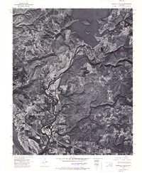
Gore serves as the primary settlement in this 1972 orthophotoquad, which uses aerial imagery to document the intricate relationship between the region's managed waterways. The landscape is defined by the massive infrastructure of the Tenkiller Ferry Dam, which impounds the waters of the Tenkiller Ferry Lake to the north. Below the dam, the Illinois River winds south through heavily wooded terrain before its confluence with the Arkansas River in the southwest corner. The photographic detail of this survey provides a precise record of land use and vegetation patterns during the early 1970s, illustrating the agricultural fields and small-scale developments that emerged around these vital river systems in Sequoyah County.
Find a feature on this map
5 named features on this map. Tap any name to fly to it.
Don’t see what you’re looking for? This feature index may not catch every label — zoom into the map to look around manually.
Map Details
Editions of this 1972 Webbers Falls SE Map
This is the sole edition of this map. No revisions or reprints were ever made.
Historical Maps of Gore Through Time
1 maps found