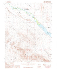
1987 Map of Weber Reservoir
USGS Topo · Published 1987About this map
The Walker River Indian Reservation dominates this landscape in western Nevada, where the lifeblood of the valley, the Walker River, flows into the expansive Weber Reservoir. This 1980s era topography shows the crucial intersection of natural water resources and regional infrastructure, notably the Southern Pacific railroad line skirting the western and southern edges of the reservation. The terrain is defined by the dramatic rise of the Wassuk Range, which transitions into lowlands like Sunshine Flat and Campbell Valley. Extensive mining activity is evident along the mountain slopes, documented through numerous prospects, a Mine Shaft, and Adits near the southern boundary. These labels suggest a history of exploration and resource extraction in the high ground overlooking the reservoir. The map also delineates the county line between Lyon and Mineral counties, marking where administrative boundaries cross this arid, resource-rich basin.
Find a feature on this map
17 named features on this map. Tap any name to fly to it.
Don’t see what you’re looking for? This feature index may not catch every label — zoom into the map to look around manually.
Map Details
Editions of this 1987 Weber Reservoir Map
This is the sole edition of this map. No revisions or reprints were ever made.
Other maps of this area

1891 · Wabuska
USGS Topo · 1:125,000

1891 · Wellington
USGS Topo · 1:125,000

1893 · Wellington
USGS Topo · 1:125,000

1894 · Wabuska
USGS Topo · 1:125,000

1908 · Carson Sink
USGS Topo · 1:250,000

1909 · Hawthorne
USGS Topo · 1:250,000

1910 · Carson Sink
USGS Topo · 1:250,000

1911 · Hawthorne
USGS Topo · 1:250,000

1915 · Hawthorne
USGS Topo · 1:250,000

1948 · Walker Lake
USGS Topo · 1:250,000