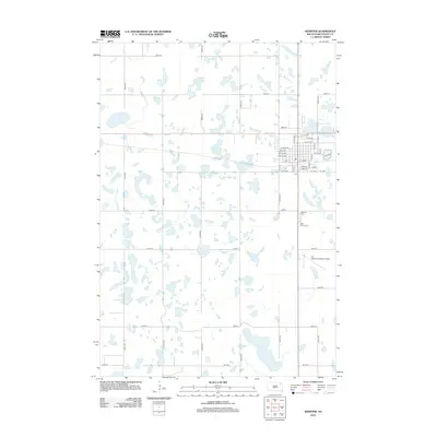
2012 Map of Webster
USGS Topo · Published 2012About this map
Glacial prairie potholes and small sloughs define the landscape surrounding the city of Webster in this 2012 study. The terrain is characterized by hundreds of small depressions filled with water, such as Buchner Slough, interspersed with a rigid grid of section-line roads including 139th St and 430th Ave. This intersection of natural hydrology and systematic agricultural surveying creates a distinct patchwork pattern typical of the eastern Dakotas. Transportation and community infrastructure are concentrated on the eastern edge of the map, where the street grid of Webster expands. Significant landmarks include the local aviation hub at The Sigurd Anderson Airport and historical burial sites like Webster Cem and Saint Otto's Cem, which serve as vital points of interest for genealogists tracing families in Day County.
Find a feature on this map
35 named features on this map. Tap any name to fly to it.
Don’t see what you’re looking for? This feature index may not catch every label — zoom into the map to look around manually.
Map Details
Editions of this 2012 Webster Map
This is the sole edition of this map. No revisions or reprints were ever made.
Other maps of this area

1953 · Milbank
USGS Topo · 1:250,000

1958 · Milbank
USGS Topo · 1:250,000

1970 · Waubay SW
USGS Topo · 1:24,000

1970 · Roslyn
USGS Topo · 1:24,000

1973 · Lily
USGS Topo · 1:24,000

1973 · Lynn Lake
USGS Topo · 1:24,000

1973 · Webster
USGS Topo · 1:24,000

1973 · Swan Lake
USGS Topo · 1:24,000

1973 · Bristol East
USGS Topo · 1:24,000
1973 · Webster NE
USGS Topo · 1:24,000