
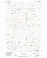
1970 Map of Waubay SW
USGS Topo · Published 1973About this map
Glacial lakes and marshy wetlands define this portion of Day County as it appeared in the early 1970s. The landscape is dominated by the sprawling waters of South Waubay Lake and Rush Lake, with the National Wildlife Management Area protecting significant habitat throughout the central and eastern sections. This environment is shaped by the complex hydrology of the prairie pothole region, where small basins and larger features like Antelope Lake and the meandering Solomon Slough dot the terrain.
Find a feature on this map
13 named features on this map. Tap any name to fly to it.
Don’t see what you’re looking for? This feature index may not catch every label — zoom into the map to look around manually.
Map Details
Editions of this 1970 Waubay SW Map
This is the sole edition of this map. No revisions or reprints were ever made.
Other maps of this area

1953 · Milbank
USGS Topo · 1:250,000

1958 · Milbank
USGS Topo · 1:250,000

1970 · Waubay
USGS Topo · 1:24,000

1970 · Florence NE
USGS Topo · 1:24,000

1970 · Roslyn
USGS Topo · 1:24,000

1970 · Enemy Swim Lake West
USGS Topo · 1:24,000

1973 · Webster
USGS Topo · 1:24,000

1973 · Swan Lake
USGS Topo · 1:24,000
1973 · Webster NE
USGS Topo · 1:24,000

1973 · Florence NW
USGS Topo · 1:24,000