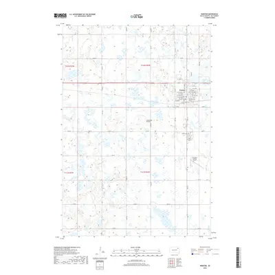
2018 Map of Webster
USGS Topo · Published 2018About this map
Webster serves as the primary hub of this glaciated landscape in Day County, situated upon the distinct geological highland known as the Coteau des Prairies. The town's grid is well-established, with streets like E 10th Ave and W 1st Ave framing the residential and commercial center. This 2018 survey reveals the town's connection to the surrounding agricultural prairie, which is punctuated by numerous wetlands and water bodies such as Buchner Slough. Local history and genealogy interest is centered around the Webster Cem and Saint Otto's Cem, both located south of the main town center. To the southeast, The Sigurd Anderson Airport provides an essential link for the region. The map captures the enduring rural character of northeastern South Dakota, where a dense network of county roads like Co Rd 21 and Co Rd 24 connects isolated farmsteads across the undulating terrain.
Find a feature on this map
39 named features on this map. Tap any name to fly to it.
Don’t see what you’re looking for? This feature index may not catch every label — zoom into the map to look around manually.
Map Details
Editions of this 2018 Webster Map
This is the sole edition of this map. No revisions or reprints were ever made.
Other maps of this area

1953 · Milbank
USGS Topo · 1:250,000

1958 · Milbank
USGS Topo · 1:250,000

1970 · Waubay SW
USGS Topo · 1:24,000

1970 · Roslyn
USGS Topo · 1:24,000

1973 · Lily
USGS Topo · 1:24,000

1973 · Lynn Lake
USGS Topo · 1:24,000

1973 · Webster
USGS Topo · 1:24,000

1973 · Swan Lake
USGS Topo · 1:24,000

1973 · Bristol East
USGS Topo · 1:24,000
1973 · Webster NE
USGS Topo · 1:24,000