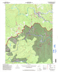
1995 Map of Webster Springs
USGS Topo · Published 1998About this map
Webster County’s rugged central highlands come into sharp focus in this mid-1990s revision of the Webster Springs area. The confluence of the Elk River and Back Fork Elk River serves as the focal point for settlement, with neighborhoods like Doortown and Cherry Falls radiating from the county seat. The landscape is a study in resource extraction and conservation, split between the industrial activity of the Parcoal quarry and numerous Strip Mines to the east, and the protected reaches of the Monongahela National Forest to the south.
Find a feature on this map
58 named features on this map. Tap any name to fly to it.
Don’t see what you’re looking for? This feature index may not catch every label — zoom into the map to look around manually.
Map Details
Editions of this 1995 Webster Springs Map
This is the sole edition of this map. No revisions or reprints were ever made.
Other maps of this area

1889 · Nicholas
USGS Topo · 1:125,000

1891 · Nicholas
USGS Topo · 1:125,000

1891 · Huntersville
USGS Topo · 1:125,000

1893 · Buckhannon
USGS Topo · 1:125,000

1893 · Sutton
USGS Topo · 1:125,000

1894 · Huntersville
USGS Topo · 1:125,000

1896 · Buckhannon
USGS Topo · 1:125,000

1897 · Buckhannon
USGS Topo · 1:125,000

1901 · Nicholas
USGS Topo · 1:125,000

1908 · Sutton
USGS Topo · 1:48,000
Featured Places
- Addison (Webster Springs), WV
- Webster Springs, Addison (Webster Springs)
- Skidmore Crossing, WV
- Bolair, WV
- Excelsior, WV