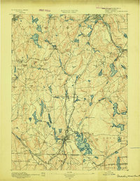
1889 Map of Webster
USGS Topo · Published 1889About this map
Industrial villages and textile hubs define the landscape along the French River and the Quinebaug River in the late nineteenth century. The town of Webster serves as a major center of activity, surrounded by specialized clusters like Merino Village, North Village, and Chaseville. These settlements are closely tied to the water power of the river valleys and the strategic reach of the Boston and Albany R. R. and the Norwich and Worcester R. R.
Find a feature on this map
130 named features on this map. Tap any name to fly to it.
Don’t see what you’re looking for? This feature index may not catch every label — zoom into the map to look around manually.
Map Details
Editions of this 1889 Webster Map
This is the sole edition of this map. No revisions or reprints were ever made.
Other maps of this area

1885 · Worcester
USGS Topo · 1:62,500

1886 · Worcester
USGS Topo · 1:62,500

1886 · Blackstone
USGS Topo · 1:62,500

1887 · Brookfield
USGS Topo · 1:62,500

1887 · Marlboro
USGS Topo · 1:62,500

1887 · Barre
USGS Topo · 1:62,500

1889 · Marlboro
USGS Topo · 1:62,500

1889 · Blackstone
USGS Topo · 1:62,500
1889 · Putnam
USGS Topo · 1:62,500
1889 · Burrillville
USGS Topo · 1:62,500