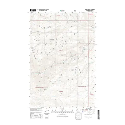
2014 Map of Weddle Canyon
USGS Topo · Published 2014About this map
Snoqualmie National Forest dominates this landscape in central Washington, where a network of steep canyons and timbered ridges defines the terrain. The Tieton River flows through the central portion of the map, accompanied by the vital infrastructure of the Yakima Tieton Main Canal, a significant water transport feature for the region's agricultural interests. Near the river's bend, local landmarks like Windy Point and Sentinel Rock provide orientation for those navigating the backcountry. Small pockets of recreation and habitation are visible at Rimrock Retreat and Trout Lodge, serving as gateways for explorers entering the surrounding wilderness. The map details numerous drainages such as Weddle Canyon, Bear Canyon, and Hoover Canyon, which feed into the primary river system. This survey also records the extensive forest road network, including Sentinel Creek Ln and several National Forest Development roads used for land management and access.
Find a feature on this map
35 named features on this map. Tap any name to fly to it.
Don’t see what you’re looking for? This feature index may not catch every label — zoom into the map to look around manually.
Map Details
Editions of this 2014 Weddle Canyon Map
This is the sole edition of this map. No revisions or reprints were ever made.
Other maps of this area

1899 · Ellensburg
USGS Topo · 1:125,000

1901 · Ellensburg
USGS Topo · 1:125,000

1902 · Mount Aix
USGS Topo · 1:125,000

1904 · Mt Aix
USGS Topo · 1:125,000

1950 · Yakima
USGS Topo · 1:250,000

1958 · Yakima
USGS Topo · 1:250,000

1961 · Yakima
USGS Topo · 1:250,000

1967 · Tieton Basin
USGS Topo · 1:24,000
1967 · Foundation Ridge
USGS Topo · 1:24,000

1971 · Nile
USGS Topo · 1:24,000