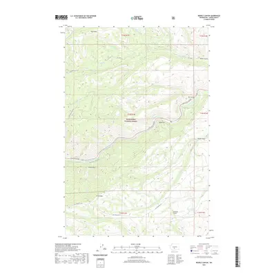
2020 Map of Weddle Canyon
USGS Topo · Published 2020About this map
Snoqualmie National Forest dominates this section of Yakima County, where the high-elevation landscape is defined by the steep descent of the Tieton River valley. The White Pass Highway follows the northern bank of the river, providing a critical transportation corridor through the forest toward Windy Point. High above the river, the Yakima Tieton Main Canal traces a complex path along the canyon walls, a testament to the region's engineering history in managing water for the arid lands to the east.
Find a feature on this map
31 named features on this map. Tap any name to fly to it.
Don’t see what you’re looking for? This feature index may not catch every label — zoom into the map to look around manually.
Map Details
Editions of this 2020 Weddle Canyon Map
This is the sole edition of this map. No revisions or reprints were ever made.
Other maps of this area

1899 · Ellensburg
USGS Topo · 1:125,000

1901 · Ellensburg
USGS Topo · 1:125,000

1902 · Mount Aix
USGS Topo · 1:125,000

1904 · Mt Aix
USGS Topo · 1:125,000

1950 · Yakima
USGS Topo · 1:250,000

1958 · Yakima
USGS Topo · 1:250,000

1961 · Yakima
USGS Topo · 1:250,000

1967 · Tieton Basin
USGS Topo · 1:24,000
1967 · Foundation Ridge
USGS Topo · 1:24,000

1971 · Nile
USGS Topo · 1:24,000