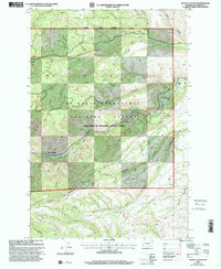
2000 Map of Weddle Canyon
USGS Topo · Published 2001About this map
Tieton River drainage defines this portion of the Yakima backcountry at the turn of the millennium, carving a deep corridor through high ridges and state-managed lands. To the north, the Oak Creek State Wildlife Area covers the slopes of Horse Ridge, while the southern reaches are marked by the steep relief of Divide Ridge. Recreation and resource management are the primary human signatures here, from the Rimrock Retreat and Windy Point Campground to several Gravel Pits and a noted Mine near the canyon floor. The map tracks the technical water management of the era, including a flume and a Footbridge crossing near Windy Point. This survey captures the boundary where the Mt Baker Snoqualmie National Forest meets state wildlife tracts, preserving the location of local landmarks like Sentinel Rock and the winding course of Counterfeit Creek.
Find a feature on this map
31 named features on this map. Tap any name to fly to it.
Don’t see what you’re looking for? This feature index may not catch every label — zoom into the map to look around manually.
Map Details
Editions of this 2000 Weddle Canyon Map
This is the sole edition of this map. No revisions or reprints were ever made.
Other maps of this area

1899 · Ellensburg
USGS Topo · 1:125,000

1901 · Ellensburg
USGS Topo · 1:125,000

1902 · Mount Aix
USGS Topo · 1:125,000

1904 · Mt Aix
USGS Topo · 1:125,000

1950 · Yakima
USGS Topo · 1:250,000

1958 · Yakima
USGS Topo · 1:250,000

1961 · Yakima
USGS Topo · 1:250,000

1967 · Tieton Basin
USGS Topo · 1:24,000
1967 · Foundation Ridge
USGS Topo · 1:24,000

1971 · Nile
USGS Topo · 1:24,000