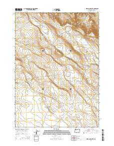
2014 Map of Weed Lake Butte
USGS Topo · Published 2014About this map
Weed Lake Butte rises above a high-desert landscape defined by ephemeral basins and essential water management in this 2014 survey. This portion of Harney County reveals a network of natural catchments and man-made impoundments critical for livestock and wildlife in the Oregon outback. Prominent features such as Prentis Lake, Marter Lake, and Leary Lake are scattered across the terrain, alongside seasonal features like Dry Lake. The distribution of these water sources, including the State Game Waterhole and Antelope Waterhole, illustrates the ongoing adaptation to this arid environment. Significant infrastructure is evident in the numerous reservoirs, such as Little Antelope Reservoir and Upper Walker Reservoir, which suggest a landscape heavily utilized for rangeland management. The map documents the intricate legal subdivisions of the Public Land Survey System, including t29s r29e and t28s r29 1/2e, providing a precise record of land tenure and drainage patterns within the Prentis Draw area.
Find a feature on this map
24 named features on this map. Tap any name to fly to it.
Don’t see what you’re looking for? This feature index may not catch every label — zoom into the map to look around manually.
Map Details
Editions of this 2014 Weed Lake Butte Map
This is the sole edition of this map. No revisions or reprints were ever made.
Other maps of this area

1955 · Burns
USGS Topo · 1:250,000

1955 · Adel
USGS Topo · 1:250,000

1957 · Adel
USGS Topo · 1:250,000

1958 · Burns
USGS Topo · 1:250,000

1958 · Adel
USGS Topo · 1:250,000

1959 · Burns
USGS Topo · 1:250,000

1962 · Adel
USGS Topo · 1:250,000

1971 · Clover Swale
USGS Topo · 1:24,000
1971 · Keg Sprs Valley East
USGS Topo · 1:24,000
1971 · Keg Sprs Valley West
USGS Topo · 1:24,000