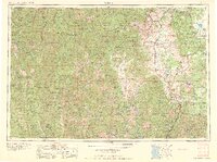
1963 Map of Weed
USGS Topo · Published 1963About this map
The Siskiyou Mountains and the volcanic peak of Mount Shasta dominate this 1963 composite survey, which captures the remote river corridors and timber-rich valleys of Northern California before modern interstate development fully transformed the region. The landscape is defined by the winding course of the Klamath River, where small settlements like Happy Camp and Seiad Valley served as isolated hubs for mining and forest service operations.
Find a feature on this map
108 named features on this map. Tap any name to fly to it.
Don’t see what you’re looking for? This feature index may not catch every label — zoom into the map to look around manually.
Map Details
Editions of this 1963 Weed Map
This is the sole edition of this map. No revisions or reprints were ever made.
Other maps of this area

1886 · Lassen Peak
USGS Topo · 1:250,000

1886 · Modoc Lava Bed
USGS Topo · 1:250,000

1886 · Shasta
USGS Topo · 1:250,000
1889 · Klamath
USGS Topo · 1:250,000

1890 · Red Bluff
USGS Topo · 1:250,000
1891 · Ashland
USGS Topo · 1:250,000

1892 · Modoc Lava-Bed
USGS Topo · 1:250,000

1892 · Lassen Peak
USGS Topo · 1:250,000
1893 · Ashland
USGS Topo · 1:250,000

1894 · Lassen Peak
USGS Topo · 1:250,000