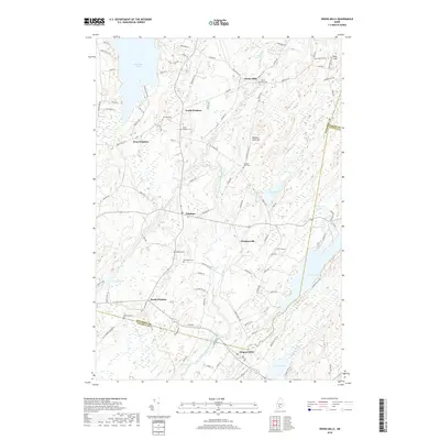
2018 Map of Weeks Mills
USGS Topo · Published 2018About this map
The W Br Sheepscot River and its various tributaries define the rural layout of this Kennebec County landscape, where small village centers are linked by winding country roads. Settlements such as Weeks Mills and Coopers Mills anchor the northern and southern reaches of the map, while Windsorville and Windsor occupy the central corridor. The area is characterized by numerous small cemeteries, including Weeks Mills Cem, Resthaven Cem, and North Windsor Cem, which offer significant value for genealogists tracing family histories in the region. To the west, the substantial waters of Threemile Pond provide a distinct contrast to the smaller ponds and bogs like Baker Bogs and Savade Pond scattered throughout the wetlands. The terrain is marked by modest rises such as Deer Hill and Windsor Neck Hill, providing a view into the contemporary geography of a traditional Maine township.
Find a feature on this map
113 named features on this map. Tap any name to fly to it.
Don’t see what you’re looking for? This feature index may not catch every label — zoom into the map to look around manually.
Map Details
Editions of this 2018 Weeks Mills Map
This is the sole edition of this map. No revisions or reprints were ever made.
Other maps of this area

1893 · Vassalboro
USGS Topo · 1:62,500

1893 · Wiscasset
USGS Topo · 1:62,500

1898 · Vassalboro
USGS Topo · 1:62,500

1913 · Waldoboro
USGS Topo · 1:48,000

1915 · Waldoboro
USGS Topo · 1:62,500

1916 · Liberty
USGS Topo · 1:62,500

1941 · Waldoboro
USGS Topo · 1:62,500

1941 · Vassalboro
USGS Topo · 1:62,500

1942 · Liberty
USGS Topo · 1:62,500

1943 · Vassalboro
USGS Topo · 1:62,500