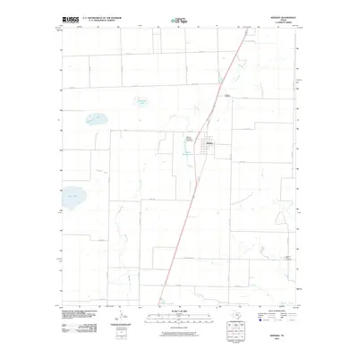
2010 Map of Weinert
USGS Topo · Published 2010About this map
The town of Weinert anchors this North Texas landscape, situated along the corridor of N Bruested and the surrounding ranch-to-market roads. This 2010 survey reflects a region defined by agricultural water management and small-town infrastructure, characterized by several named reservoirs such as Harlan Weinert Lake, which is contained by the Harlan Weinert Lake Dam. The terrain is drained by the winding course of Lake Creek and Millers Creek, with family-named or location-based water bodies like Thompson Lake, Winchester Lake, and Zahn Lake dotting the plains. Genealogists and local historians will find the exact locations of the Weinert Cemetery and Pleasant Valley Cemetery significant for tracing family ties to this portion of Haskell County. The map provides a detailed view of the rural road network, from established routes like Ranch Rd 1080 to smaller thoroughfares such as Lake Creek Rd, illustrating the modern layout of these historic Texas ranchlands.
Find a feature on this map
34 named features on this map. Tap any name to fly to it.
Don’t see what you’re looking for? This feature index may not catch every label — zoom into the map to look around manually.
Map Details
Editions of this 2010 Weinert Map
This is the sole edition of this map. No revisions or reprints were ever made.
Other maps of this area

1954 · Wichita Falls
USGS Topo · 1:250,000

1958 · Wichita Falls
USGS Topo · 1:250,000

1966 · Haskell
USGS Topo · 1:24,000
1966 · Pinkerton
USGS Topo · 1:24,000
1966 · Irby
USGS Topo · 1:24,000

1967 · Rochester
USGS Topo · 1:24,000

1967 · Weinert
USGS Topo · 1:24,000

1967 · Mattson
USGS Topo · 1:24,000

1968 · Munday West
USGS Topo · 1:24,000
1968 · Munday East
USGS Topo · 1:24,000