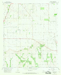
1966 Map of Pinkerton
USGS Topo · Published 1969About this map
Pinkerton serves as the focal point of this Haskell County landscape during the mid-1960s, a period defined by the convergence of agricultural land use and petroleum extraction. The Weinert Oil Field and the Sojourner district dominate the eastern half of the quadrangle, where numerous wells and a Pumping Sta indicate the region's industrial importance. The western edge is defined by the corridor of the Atchison Topeka and Santa Fe railroad, which historically shaped the transport and settlement patterns of the Texas plains.
Find a feature on this map
12 named features on this map. Tap any name to fly to it.
Don’t see what you’re looking for? This feature index may not catch every label — zoom into the map to look around manually.
Map Details
Editions of this 1966 Pinkerton Map
2 editions found
Other maps of this area

1925 · Haskell 3-b
USGS Topo · 1:48,000

1954 · Wichita Falls
USGS Topo · 1:250,000

1958 · Wichita Falls
USGS Topo · 1:250,000

1964 · Sagerton
USGS Topo · 1:24,000

1965 · Jud
USGS Topo · 1:24,000

1966 · Haskell
USGS Topo · 1:24,000
1966 · Dudleys Creek
USGS Topo · 1:24,000
1966 · Lake Stamford West
USGS Topo · 1:24,000

1967 · Rochester
USGS Topo · 1:24,000

1967 · Weinert
USGS Topo · 1:24,000