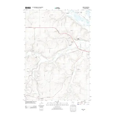
2013 Map of Welch
USGS Topo · Published 2013About this map
The Cannon River valley and its surrounding ridges dominate this landscape between the settlements of Welch and Vasa. The terrain is characterized by the confluence of Belle Creek and Spring Cr into the main river channel, creating a complex network of bluffs and lowlands that support both agriculture and recreation. In the northern reaches, the Mississippi River floodplain influence is visible through water bodies like Goose Lake and Indian Slough near Eggleston. Local history is preserved in several denominational and community landmarks, including the Swedish Methodist Episcopal Cem and Messiah Episcopal Cem. The map captures a moment of modern land use where traditional rural life intersects with seasonal recreation at the Welch Village Ski Area, all connected by a grid of county roads and historic corridors like Highway 61 Blvd.
Find a feature on this map
73 named features on this map. Tap any name to fly to it.
Don’t see what you’re looking for? This feature index may not catch every label — zoom into the map to look around manually.
Map Details
Editions of this 2013 Welch Map
This is the sole edition of this map. No revisions or reprints were ever made.
Other maps of this area

1944 · Red Wing
USGS Topo · 1:62,500

1952 · Red Wing
USGS Topo · 1:62,500

1953 · Saint Paul
USGS Topo · 1:250,000

1957 · Hastings
USGS Topo · 1:62,500

1959 · Saint Paul
USGS Topo · 1:250,000

1968 · Goodhue East
USGS Topo · 1:24,000

1968 · White Rock
USGS Topo · 1:24,000
1968 · Goodhue West
USGS Topo · 1:24,000
1974 · Miesville
USGS Topo · 1:24,000
1974 · Red Wing
USGS Topo · 1:24,000