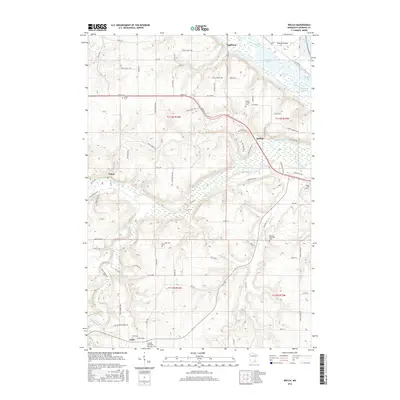
2016 Map of Welch
USGS Topo · Published 2016About this map
Eggleston and the surrounding river bottomlands define this portion of Goodhue County, where the Vermillion River and Cannon River converge toward the Mississippi. This survey reveals a landscape deeply connected to its water systems, including complex backwaters like Indian Slough, Wildcat Lake, and Goose Lake. The upland areas are marked by significant genealogical landmarks, including the Vasa Cem and the Swedish Methodist Episcopal Cem near the settlement of Vasa. These sites, along with the Messiah Episcopal Cem, speak to the early Scandinavian immigrant heritage of the region. Transportation routes follow the natural topography, with CO 19 Blvd and CO 18 Blvd connecting the riverside communities of Welch and Harliss to the broader agricultural plateaus.
Find a feature on this map
90 named features on this map. Tap any name to fly to it.
Don’t see what you’re looking for? This feature index may not catch every label — zoom into the map to look around manually.
Map Details
Editions of this 2016 Welch Map
This is the sole edition of this map. No revisions or reprints were ever made.
Other maps of this area

1944 · Red Wing
USGS Topo · 1:62,500

1952 · Red Wing
USGS Topo · 1:62,500

1953 · Saint Paul
USGS Topo · 1:250,000

1957 · Hastings
USGS Topo · 1:62,500

1959 · Saint Paul
USGS Topo · 1:250,000

1968 · Goodhue East
USGS Topo · 1:24,000

1968 · White Rock
USGS Topo · 1:24,000
1968 · Goodhue West
USGS Topo · 1:24,000
1974 · Miesville
USGS Topo · 1:24,000
1974 · Red Wing
USGS Topo · 1:24,000