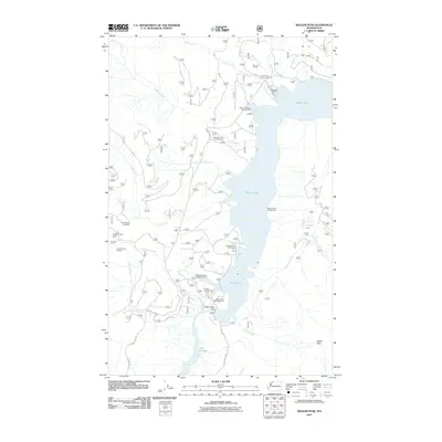
2011 Map of Welker Peak
USGS Topo · Published 2011About this map
Baker Lake serves as the central focal point of this recreational and hydrological landscape, held in place by the Upper Baker Dam. The shoreline is heavily developed for public use, featuring a network of sites such as the Maple Grove Campground, Horseshoe Cove Campground, and the Baker Lake Resort. In the northern reach, the Morovitz Ranch sits near the confluence of Morovitz Creek and Park Creek, indicating early land use in the river valley.
Find a feature on this map
31 named features on this map. Tap any name to fly to it.
Don’t see what you’re looking for? This feature index may not catch every label — zoom into the map to look around manually.
Map Details
Editions of this 2011 Welker Peak Map
This is the sole edition of this map. No revisions or reprints were ever made.
Other maps of this area

1909 · Mt Baker
USGS Topo · 1:192,000

1915 · Mt. Baker
USGS Topo · 1:250,000

1952 · Lake Shannon
USGS Topo · 1:62,500

1952 · Mt. Baker
USGS Topo · 1:62,500

1952 · Hamilton
USGS Topo · 1:62,500

1953 · Mt Shuksan
USGS Topo · 1:62,500

1955 · Concrete
USGS Topo · 1:250,000

1958 · Concrete
USGS Topo · 1:250,000

1962 · Concrete
USGS Topo · 1:250,000
1973 · Hamilton
USGS Topo · 1:62,500