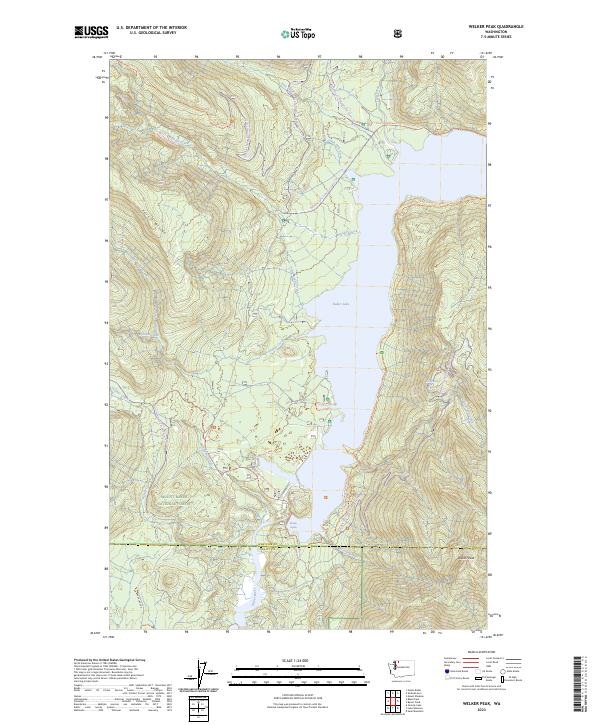
2023 Map of Welker Peak
USGS Topo · Published 2023About this map
Baker Lake dominates this mountain landscape, its northern waters fed by a complex drainage system including Park Creek, Swift Creek, and Boulder Creek. The map shows a clear division between the high-altitude Mount Baker Wilderness to the northwest and the Mount Baker National Forest surrounding the lake. Recreational infrastructure is prominent, featuring the Pacific NW National Scenic Trl tracing the eastern shoreline and specialized routes like the Boulder Ridge X-Country Ski Trl and the Loomis-Nooksack Snowmobile Trail. Downstream of the lake, the Baker River flows past Marble Rapids at the Whatcom Co / Skagit Co line. This 2023 survey documents the intersection of modern timber management, conservation boundaries, and back-country access near the prominent Welker Peak.
Find a feature on this map
43 named features on this map. Tap any name to fly to it.
Don’t see what you’re looking for? This feature index may not catch every label — zoom into the map to look around manually.
Map Details
Editions of this 2023 Welker Peak Map
This is the sole edition of this map. No revisions or reprints were ever made.
Other maps of this area

1909 · Mt Baker
USGS Topo · 1:192,000

1915 · Mt. Baker
USGS Topo · 1:250,000

1952 · Lake Shannon
USGS Topo · 1:62,500

1952 · Mt. Baker
USGS Topo · 1:62,500

1952 · Hamilton
USGS Topo · 1:62,500

1953 · Mt Shuksan
USGS Topo · 1:62,500

1955 · Concrete
USGS Topo · 1:250,000

1958 · Concrete
USGS Topo · 1:250,000

1962 · Concrete
USGS Topo · 1:250,000
1973 · Hamilton
USGS Topo · 1:62,500