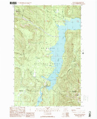
1989 Map of Welker Peak
USGS Topo · Published 1989About this map
Baker Lake and the northern reaches of Lake Shannon dominate this 1989 topographic study of the North Cascades. The landscape is defined by the hydroelectric infrastructure of the Upper Baker Dam, which regulates the waters between the two reservoirs. While much of the terrain is protected within the Mt Baker Wilderness and Mt Baker National Forest, the map also records the footprints of resource extraction through several Quarries and a Gravel Pit.
Find a feature on this map
32 named features on this map. Tap any name to fly to it.
Don’t see what you’re looking for? This feature index may not catch every label — zoom into the map to look around manually.
Map Details
Editions of this 1989 Welker Peak Map
This is the sole edition of this map. No revisions or reprints were ever made.
Other maps of this area

1909 · Mt Baker
USGS Topo · 1:192,000

1915 · Mt. Baker
USGS Topo · 1:250,000

1952 · Lake Shannon
USGS Topo · 1:62,500

1952 · Mt. Baker
USGS Topo · 1:62,500

1952 · Hamilton
USGS Topo · 1:62,500

1953 · Mt Shuksan
USGS Topo · 1:62,500

1955 · Concrete
USGS Topo · 1:250,000

1958 · Concrete
USGS Topo · 1:250,000

1962 · Concrete
USGS Topo · 1:250,000
1973 · Hamilton
USGS Topo · 1:62,500