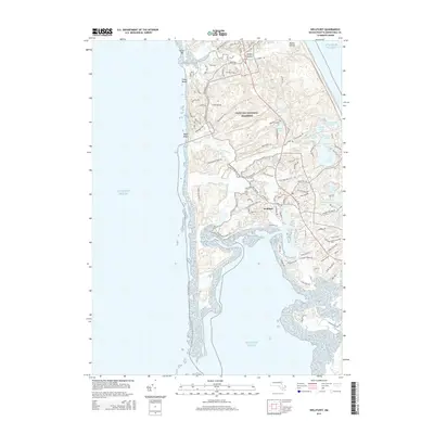
2015 Map of Wellfleet
USGS Topo · Published 2015About this map
Wellfleet and the surrounding Pamet Hollow landscape are detailed in this 2015 study, showing the modern composition of this storied Cape Cod maritime community. The geography is defined by its numerous freshwater kettle ponds, such as Great Pond, Gull Pond, and Long Pond, which dot the terrain east of the village center. Much of the land is preserved within the Cape Cod National Seashore, protecting the coastal dunes and marshes that transition from the Atlantic Ocean to the interior waterways. The map traces the intricate drainage systems of the Herring River and Bound Brook, while local road networks like Bound Brook Island Rd and Ryder Beach Rd connect historical settlements to the shoreline at Ryder Beach and Fisher Beach. This recent survey provides a precise look at the contemporary interface between the residential village and its surrounding protected wilderness.
Find a feature on this map
80 named features on this map. Tap any name to fly to it.
Don’t see what you’re looking for? This feature index may not catch every label — zoom into the map to look around manually.
Map Details
Editions of this 2015 Wellfleet Map
This is the sole edition of this map. No revisions or reprints were ever made.
Other maps of this area

1887 · Wellfleet
USGS Topo · 1:62,500

1887 · Provincetown
USGS Topo · 1:62,500

1889 · Provincetown
USGS Topo · 1:62,500

1889 · Wellfleet
USGS Topo · 1:62,500

1893 · Wellfleet
USGS Topo · 1:62,500

1898 · Provincetown
USGS Topo · 1:62,500

1942 · Cape Cod Bay
USGS Topo · 1:125,000

1942 · Nauset
USGS Topo · 1:125,000

1944 · Orleans
USGS Topo · 1:31,680

1944 · Provincetown
USGS Topo · 1:31,680