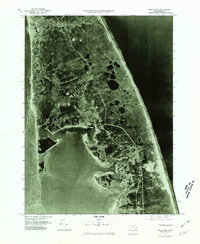
1977 Map of Wellfleet
USGS Topo · Published 1981About this map
The narrow, curving reach of the Outer Cape is captured in this 1977 orthophotograph, providing a high-contrast look at the interaction between sand, marsh, and sea. Centered on Wellfleet, the imagery reveals the complex tidal inlets and marshlands that define the inner coastline along Cape Cod Bay. Moving east toward the Atlantic Ocean, the landscape transitions into the high coastal dunes and kettle ponds characteristic of this terminal moraine environment. Smaller settlements like South Truro, Truro, and South Wellfleet are visible as clusters of development along the road networks that parallel the shore. The photograph, produced by the Geological Survey and the Commonwealth of Massachusetts Department of Public Works, offers an unfiltered view of the coastal geography before decades of subsequent erosion and residential growth altered these fragile shorelines.
Find a feature on this map
7 named features on this map. Tap any name to fly to it.
Don’t see what you’re looking for? This feature index may not catch every label — zoom into the map to look around manually.
Map Details
Editions of this 1977 Wellfleet Map
This is the sole edition of this map. No revisions or reprints were ever made.
Other maps of this area

1887 · Wellfleet
USGS Topo · 1:62,500

1887 · Provincetown
USGS Topo · 1:62,500

1889 · Provincetown
USGS Topo · 1:62,500

1889 · Wellfleet
USGS Topo · 1:62,500

1893 · Wellfleet
USGS Topo · 1:62,500

1898 · Provincetown
USGS Topo · 1:62,500

1942 · Cape Cod Bay
USGS Topo · 1:125,000

1942 · Nauset
USGS Topo · 1:125,000

1944 · Orleans
USGS Topo · 1:31,680

1944 · Wellfleet
USGS Topo · 1:31,680