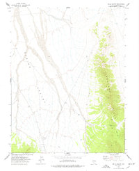
1973 Map of Wells Summit
USGS Topo · Published 1977About this map
Spring Valley dominates the western half of this 1970s topographical record, showing a vast alluvial basin defined by drainage patterns and isolation. The eastern horizon is anchored by the Limestone Hills, where the terrain rises sharply to Wells Summit. The landscape is largely undeveloped, characterized by a network of ranching or mining access routes labeled simply as Jeep Trail.
Find a feature on this map
10 named features on this map. Tap any name to fly to it.
Don’t see what you’re looking for? This feature index may not catch every label — zoom into the map to look around manually.
Map Details
Editions of this 1973 Wells Summit Map
This is the sole edition of this map. No revisions or reprints were ever made.
Other maps of this area

1956 · Lund
USGS Topo · 1:250,000

1960 · Lund
USGS Topo · 1:250,000

1972 · Rosencrans Knolls
USGS Topo · 1:24,000

1972 · Hyde Well
USGS Topo · 1:24,000

1972 · Big Springs
USGS Topo · 1:24,000

1973 · Horse Corral Pass
USGS Topo · 1:24,000

1973 · Atlanta
USGS Topo · 1:24,000

1973 · Indian Springs Knolls
USGS Topo · 1:24,000

1973 · Red Ledges
USGS Topo · 1:24,000
1978 · The Gouge Eye
USGS Topo · 1:24,000