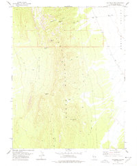
1978 Map of The Gouge Eye
USGS Topo · Published 1978About this map
The Fortification Range dominates this 1970s landscape in eastern Nevada, characterized by a complex network of canyons and high-elevation springs. A topographic feature known as The Gouge Eye defines the central terrain, while the eastern edge descends into the broad expanse of Spring Valley. The distribution of water sources like Fortification Spring and the aptly named Cow Heaven Spring (Dry) highlights the reliance on specific points of hydration for any activity in this arid environment.
Find a feature on this map
13 named features on this map. Tap any name to fly to it.
Don’t see what you’re looking for? This feature index may not catch every label — zoom into the map to look around manually.
Map Details
Editions of this 1978 The Gouge Eye Map
This is the sole edition of this map. No revisions or reprints were ever made.
Other maps of this area

1956 · Lund
USGS Topo · 1:250,000

1960 · Lund
USGS Topo · 1:250,000

1973 · Gouge Eye Well
USGS Topo · 1:24,000

1973 · Horse Corral Pass
USGS Topo · 1:24,000

1973 · Atlanta
USGS Topo · 1:24,000

1973 · Indian Springs Knolls
USGS Topo · 1:24,000
1973 · Mustang Well
USGS Topo · 1:24,000
1973 · Mount Grafton NE
USGS Topo · 1:24,000

1973 · Red Ledges
USGS Topo · 1:24,000
1973 · Wells Summit
USGS Topo · 1:24,000