
1957 Map of Wenatchee
USGS Topo · Published 1973About this map
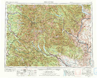
Wenatchee and the Columbia River corridor anchor the eastern edge of this mid-century survey, where the valley's orchards and orchards met the industrial expansion of Appleyard and Rock Island. The map meticulously charts the transportation arteries that conquered the Cascade Range, showing the Great Northern RR crossing through Scenic and Berne alongside U.S. 2, while the Milwaukee Road and the Northern Pacific RR traverse the southern passes.
Find a feature on this map
163 named features on this map. Tap any name to fly to it.
Don’t see what you’re looking for? This feature index may not catch every label — zoom into the map to look around manually.
Map Details
Editions of this 1957 Wenatchee Map
2 editions found
Other maps of this area

1895 · Snohomish
USGS Topo · 1:125,000

1897 · Mount Stuart
USGS Topo · 1:125,000

1897 · Tacoma
USGS Topo · 1:125,000

1897 · Seattle
USGS Topo · 1:125,000

1899 · Glacier Peak
USGS Topo · 1:125,000

1899 · Stillaguamish
USGS Topo · 1:125,000

1899 · Ellensburg
USGS Topo · 1:125,000

1899 · Methow
USGS Topo · 1:125,000

1900 · Tacoma
USGS Topo · 1:125,000

1901 · Glacier Peak
USGS Topo · 1:125,000