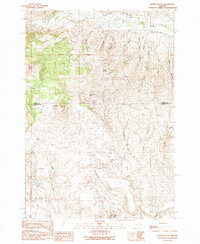
1990 Map of Wendt Butte
USGS Topo · Published 1990About this map
The Golden Eagle Mine sits in the southern reaches of this high-desert landscape, reflecting the long-standing mineral interest that has shaped the borderlands between Baker Co and Malheur Co. The terrain is defined by a series of prominent elevations, including Wendt Butte, Three Pine Butte, and Baldy Mountain, which tower over dry gulches and seasonal water sources. The Burnt River flows through the northern section, fed by a network of drainages such as McPherson Creek and Stack Mahogany Creek. This 1990 provisional survey documents the intricate system of springs, including Koonitz Spring and Cave Hollow Spring, which were vital for sustaining ranching and prospecting in this isolated region. Large plateaus like Mahogany Flat and Schofield Flat offer a contrast to the steep ravines of Evans Gulch and Porter Gulch.
Find a feature on this map
36 named features on this map. Tap any name to fly to it.
Don’t see what you’re looking for? This feature index may not catch every label — zoom into the map to look around manually.
Map Details
Editions of this 1990 Wendt Butte Map
This is the sole edition of this map. No revisions or reprints were ever made.
Other maps of this area

1901 · Baker City
USGS Topo · 1:125,000

1955 · Baker
USGS Topo · 1:250,000

1959 · Baker
USGS Topo · 1:250,000

1964 · Bridgeport
USGS Topo · 1:62,500

1964 · Ironside
USGS Topo · 1:62,500

1967 · French Gulch
USGS Topo · 1:24,000

1967 · Dooley Mtn
USGS Topo · 1:24,000
1967 · Brannan Gulch
USGS Topo · 1:24,000

1980 · Brogan
USGS Topo · 1:100,000

1981 · Baker
USGS Topo · 1:100,000