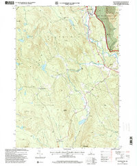
1995 Map of Wentworth
USGS Topo · Published 2000About this map
The Baker River valley defines the eastern edge of this mid-1990s survey, where the settlement of Wentworth serves as a primary local hub. The landscape is heavily wooded and mountainous, much of it protected within the White Mountain National Forest and Province Road State Forest. Infrastructure along the river includes a Flood Control Dam and a Gaging Station, illustrating the hydraulic management of the region.
Find a feature on this map
42 named features on this map. Tap any name to fly to it.
Don’t see what you’re looking for? This feature index may not catch every label — zoom into the map to look around manually.
Map Details
Editions of this 1995 Wentworth Map
This is the sole edition of this map. No revisions or reprints were ever made.
Other maps of this area

1927 · Cardigan
USGS Topo · 1:62,500

1927 · Mascoma
USGS Topo · 1:62,500

1928 · Rumney
USGS Topo · 1:62,500

1930 · Cardigan
USGS Topo · 1:62,500

1931 · Mt. Cube
USGS Topo · 1:62,500

1932 · Mascoma
USGS Topo · 1:62,500

1932 · Rumney
USGS Topo · 1:62,500

1933 · Mt. Cube
USGS Topo · 1:62,500

1949 · Portland
USGS Topo · 1:250,000

1950 · Glens Falls
USGS Topo · 1:250,000