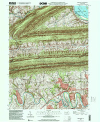
1999 Map of Wertzville
USGS Topo · Published 2001About this map
Cove Mountain and Blue Mountain dominate the central landscape of this Perry and Cumberland County border region, creating a dramatic series of ridgelines separated by the Fishing Creek and Trout Run valleys. The northern portion of the map follows the winding path of Sherman Creek through Dellville, where the Dellville Church stands near the water. Further south, the Conodoguinet Creek meanders through the townships of Middlesex and Silver Spring, passing historic landmarks such as Hustons Mill and several local educational sites including Eckels School and Summers School. The Appalachian National Scenic Trail traverses the crest of the ridges, offering a perspective on the contrast between the protected State Game Lands No 170 and the agricultural settlements like Wertzville and Donnallytown that occupy the lower fertile basins.
Find a feature on this map
33 named features on this map. Tap any name to fly to it.
Don’t see what you’re looking for? This feature index may not catch every label — zoom into the map to look around manually.
Map Details
Editions of this 1999 Wertzville Map
This is the sole edition of this map. No revisions or reprints were ever made.
Other maps of this area

1892 · Harrisburg
USGS Topo · 1:62,500

1899 · Harrisburg
USGS Topo · 1:62,500

1904 · Carlisle
USGS Topo · 1:62,500

1906 · New Cumberland
USGS Topo · 1:62,500

1907 · New Bloomfield
USGS Topo · 1:62,500

1924 · Harrisburg
USGS Topo · 1:62,500

1943 · New Cumberland
USGS Topo · 1:62,500

1943 · Harrisburg
USGS Topo · 1:62,500

1943 · New Bloomfield
USGS Topo · 1:62,500

1943 · Carlisle
USGS Topo · 1:62,500
Featured Places
- Middlesex Township, PA
- Penn Township, PA
- Dellville, Wheatfield Township
- Wertzville, Silver Spring Township
- Wheatfield Township, PA