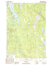
1990 Map of Wesley
USGS Topo · Published 1990About this map
Wesley Fire Tower stands as a prominent landmark over this portion of Washington County, overlooking a landscape defined by an intricate network of waterways and timberland boundaries. The township of Wesley serves as the central hub, situated near Day Hill and the small settlement at The Pines. This map documents a region heavily utilized for its natural resources and water access, evidenced by the presence of a Sand & Gravel Pit and a Boat Ramp on the eastern shore of First Chain Lake.
Find a feature on this map
35 named features on this map. Tap any name to fly to it.
Don’t see what you’re looking for? This feature index may not catch every label — zoom into the map to look around manually.
Map Details
Editions of this 1990 Wesley Map
This is the sole edition of this map. No revisions or reprints were ever made.
Other maps of this area

1941 · Wesley
USGS Topo · 1:62,500

1941 · Tug Mountain
USGS Topo · 1:62,500

1941 · Big Lake
USGS Topo · 1:62,500

1941 · Wabassus Lake
USGS Topo · 1:62,500

1943 · Big Lake
USGS Topo · 1:62,500

1943 · Tug Mountain
USGS Topo · 1:62,500

1943 · Wesley
USGS Topo · 1:62,500

1943 · Wabassus Lake
USGS Topo · 1:62,500

1952 · Big Lake
USGS Topo · 1:50,000

1953 · Wabassus Lake
USGS Topo · 1:62,500