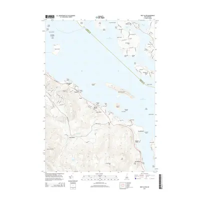
2015 Map of West Alton
USGS Topo · Published 2015About this map
Lake Winnipesaukee dominates the northern half of this landscape, its expansive waters punctuated by numerous landforms including the large Rattlesnake Island and the inhabited stretches of Tuftonboro Neck. Along the southwestern shore, several distinct lakefront communities like Spring Haven, Samoset, and Lake Shore Park line the coastal roads, reflecting the area's development as a premier seasonal destination. The presence of Railroad Ave near the shore hints at the transportation history that once brought visitors to the water's edge.
Find a feature on this map
120 named features on this map. Tap any name to fly to it.
Don’t see what you’re looking for? This feature index may not catch every label — zoom into the map to look around manually.
Map Details
Editions of this 2015 West Alton Map
This is the sole edition of this map. No revisions or reprints were ever made.
Other maps of this area

1909 · Winnepesaukee
USGS Topo · 1:62,500

1919 · Gilmanton
USGS Topo · 1:62,500

1919 · Alton
USGS Topo · 1:62,500

1927 · Gilmanton
USGS Topo · 1:62,500

1928 · Wolfeboro
USGS Topo · 1:62,500

1949 · Portland
USGS Topo · 1:250,000

1956 · Winnipesaukee
USGS Topo · 1:62,500

1956 · Portland
USGS Topo · 1:250,000

1957 · Alton
USGS Topo · 1:62,500
1957 · Gilmanton
USGS Topo · 1:62,500