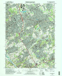
1996 Map of West Chester
USGS Topo · Published 1996About this map
West Chester serves as the dense hub of this mid-1990s survey, showing a landscape defined by collegiate institutions and residential expansion. The campus of West Chester University and the specialized Cheyney University highlight the area's educational focus, while the presence of West Chester Reservoir and the Brandywine Airport indicates a well-established suburban infrastructure. The road network, including the prominent Wilmington Pike and Strasburg Road, connects a series of older hamlets such as Dilworthtown, Thornton, and Goshenville.
Find a feature on this map
113 named features on this map. Tap any name to fly to it.
Don’t see what you’re looking for? This feature index may not catch every label — zoom into the map to look around manually.
Map Details
Editions of this 1996 West Chester Map
This is the sole edition of this map. No revisions or reprints were ever made.
Other maps of this area

1894 · Chester
USGS Topo · 1:62,500

1894 · Norristown
USGS Topo · 1:62,500

1895 · Norristown
USGS Topo · 1:62,500

1896 · Norristown
USGS Topo · 1:62,500

1896 · Chester
USGS Topo · 1:62,500

1898 · Chester
USGS Topo · 1:62,500

1901 · Camden
USGS Topo · 1:125,000

1901 · West Chester
USGS Topo · 1:62,500

1904 · West Chester
USGS Topo · 1:62,500

1906 · Phoenixville
USGS Topo · 1:62,500
Featured Places
- West Goshen Township, PA
- West Chester, PA
- Willistown Township, PA
- Westtown, Thornbury Township
- Birmingham Township, PA