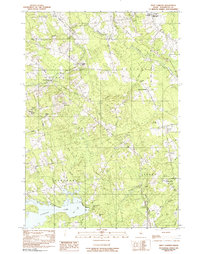
1981 Map of West Corinth
USGS Topo · Published 1982About this map
Kenduskeag Stream flows through this Penobscot County landscape, anchoring a rural network of small agricultural and milling settlements in the late 20th century. The village of Exeter Mills sits at a focal point of local activity, while East Corinth and West Corinth serve as residential hubs for the surrounding townships. This 1981 survey reveals a landscape deeply connected to its local history through numerous family and community burial grounds, including the Corinthian Cem, Tibbets Cem, and No Exeter Cem.
Find a feature on this map
51 named features on this map. Tap any name to fly to it.
Don’t see what you’re looking for? This feature index may not catch every label — zoom into the map to look around manually.
Map Details
Editions of this 1981 West Corinth Map
This is the sole edition of this map. No revisions or reprints were ever made.
Other maps of this area

1902 · Bangor
USGS Topo · 1:62,500

1931 · Stetson
USGS Topo · 1:48,000

1932 · Dover-Foxcroft
USGS Topo · 1:48,000

1933 · Boyd Lake
USGS Topo · 1:62,500

1935 · Dover-Foxcroft
USGS Topo · 1:62,500

1935 · Stetson
USGS Topo · 1:62,500

1942 · Bangor
USGS Topo · 1:62,500

1946 · Bangor
USGS Topo · 1:62,500

1948 · Bangor
USGS Topo · 1:250,000

1951 · Boyd Lake
USGS Topo · 1:50,000