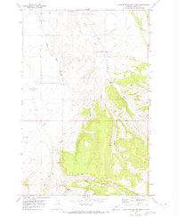
1970 Map of West Fork Beaver Creek
USGS Topo · Published 1973About this map
Beaver Creek Sch and Rock Creek Sch stand as the primary community hubs in this rural Fergus County landscape, mapped as it appeared in the late 1960s. The terrain is defined by the intricate branching of the Beaver Creek and Rock Creek systems, including the West Fork Beaver Creek, Middle Fork Beaver Creek, and West Fork Rock Creek. These drainage patterns dictated the placement of early 20th-century rural infrastructure, from the Beaver Creek Cem on a ridge above the water to the various Gravel Pits and a solitary Mine located in the southern uplands. Land use is further illustrated by a major Pipeline cutting across the northern half of the quadrangle and numerous springs, such as the cluster of Springs near the northern border, which provided essential water sources for the cattle ranching operations that characterize this part of Montana.
Find a feature on this map
18 named features on this map. Tap any name to fly to it.
Don’t see what you’re looking for? This feature index may not catch every label — zoom into the map to look around manually.
Map Details
Editions of this 1970 West Fork Beaver Creek Map
This is the sole edition of this map. No revisions or reprints were ever made.
Other maps of this area

1889 · Big Snowy Mountain
USGS Topo · 1:250,000

1893 · Big Snowy Mountain
USGS Topo · 1:250,000

1941 · Lewistown
USGS Topo · 1:62,500

1944 · Lewistown
USGS Topo · 1:62,500

1954 · Roundup
USGS Topo · 1:250,000

1954 · Lewistown
USGS Topo · 1:250,000

1958 · Roundup
USGS Topo · 1:250,000

1959 · Lewistown
USGS Topo · 1:250,000

1970 · Glengarry
USGS Topo · 1:24,000

1970 · Crystal Lake
USGS Topo · 1:24,000