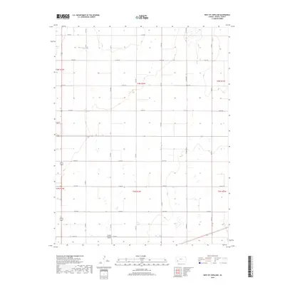
2018 Map of West of Copeland
USGS Topo · Published 2018About this map
The agricultural grid of Haskell County dominates this landscape, showing the precise organization of the High Plains. Transport and infrastructure are centered around the Sublette Municipal Airport in the south, while the rest of the quadrangle is defined by a rigorous network of section-line roads. This systematic layout includes thoroughfares such as Co Rd 100 and Co Rd 150, which facilitate the movement of goods and machinery across this productive farming region. The map reveals the relationship between modern aviation and traditional land division, where even the runways are aligned with the historical township and range system. This 2018 survey provides a clear view of the rural infrastructure that supports the local economy, from the intersections of Co Rd NN to the southern boundary along Co Rd 170.
Find a feature on this map
21 named features on this map. Tap any name to fly to it.
Don’t see what you’re looking for? This feature index may not catch every label — zoom into the map to look around manually.
Map Details
Editions of this 2018 West of Copeland Map
This is the sole edition of this map. No revisions or reprints were ever made.
Other maps of this area

1896 · Garden
USGS Topo · 1:125,000

1955 · Dodge City
USGS Topo · 1:250,000

1958 · Dodge City
USGS Topo · 1:250,000

1959 · Dodge City
USGS Topo · 1:250,000

1959 · Garden City 3 NW
USGS Topo · 1:24,000

1959 · Garden City 3 NE
USGS Topo · 1:24,000

1960 · Garden City 3 SW
USGS Topo · 1:24,000

1960 · Garden City 3 SE
USGS Topo · 1:24,000

1968 · Plains NW
USGS Topo · 1:24,000
1968 · Satanta
USGS Topo · 1:24,000