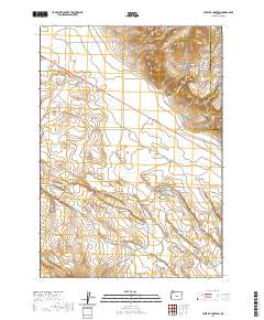
2020 Map of West of Hampton
USGS Topo · Published 2020About this map
Hampton Buttes dominate the northeastern corner of this arid landscape, rising sharply from the surrounding high plains. Located along the boundary between Deschutes and Crook Counties, the area is characterized by the expansive High Desert terrain that stretches across much of the central and southern portions of the map. Water is scarce in this environment, represented primarily by the seasonal drainages of Lizard Cr and Desert Cr.
Find a feature on this map
11 named features on this map. Tap any name to fly to it.
Don’t see what you’re looking for? This feature index may not catch every label — zoom into the map to look around manually.
Map Details
Editions of this 2020 West of Hampton Map
This is the sole edition of this map. No revisions or reprints were ever made.
Other maps of this area

1955 · Crescent
USGS Topo · 1:250,000

1957 · Crescent
USGS Topo · 1:250,000

1958 · Crescent
USGS Topo · 1:250,000

1970 · Crescent
USGS Topo · 1:250,000

1983 · Potato Lake
USGS Topo · 1:24,000

1983 · Hampton Butte
USGS Topo · 1:24,000

1983 · Imperial Valley South
USGS Topo · 1:24,000

1983 · Benjamin Lake
USGS Topo · 1:24,000

1983 · West of Hampton
USGS Topo · 1:24,000
1983 · Frederick Butte
USGS Topo · 1:24,000