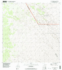
1993 Map of West Of Kokoolau
USGS Topo · Published 2003About this map
Volcanic activity defines the landscape of this region on Hawaii Island, where the Lava Flow of 1859 cuts a prominent path across the high-elevation terrain. This survey reflects the mid-20th-century transition of traditional land divisions into modern administrative and military use. The north is dominated by the Pohakuloa Training Area, while the central and southern reaches include vast protected areas such as the Kaohe Forest Reserve and the Mauna Loa Game Reserve. Large ahupua'a like Keauhou 2 remain legible beneath the network of unimproved roads and specialized tracks, including the Bobcat Trail and the remote Kona Highway (14wd). The map provides a look at the intersection of geology and conservation at the end of the century.
Find a feature on this map
12 named features on this map. Tap any name to fly to it.
Don’t see what you’re looking for? This feature index may not catch every label — zoom into the map to look around manually.
Map Details
Editions of this 1993 West Of Kokoolau Map
This is the sole edition of this map. No revisions or reprints were ever made.
Other maps of this area

1927 · Kaohe
USGS Topo · 1:62,500

1928 · Kailua
USGS Topo · 1:62,500

1928 · Mauna Loa
USGS Topo · 1:62,500

1930 · Kaohe
USGS Topo · 1:62,500

1954 · Hawaii South
USGS Topo · 1:250,000

1954 · Hawaii North
USGS Topo · 1:250,000

1956 · Puu Koli
USGS Topo · 1:24,000

1956 · Puu O Uo
USGS Topo · 1:24,000
1956 · Kokoolau
USGS Topo · 1:24,000

1956 · Naohueleelua
USGS Topo · 1:24,000