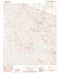
1988 Map of West of Quitobaquito Springs
USGS Topo · Published 1988About this map
The United States-Mexico international border bisects this landscape, creating a stark cartographic division between the desert terrain of Pima Co, Arizona, and the state of Sonora, Mexico. Much of the northern territory is dedicated to conservation and military use, primarily within the Cabeza Prieta National Wildlife Refuge and the southern reaches of the Luke Air Force Range. This 1988 provisional survey captures a vast, arid environment where the ephemeral waters of the Sonoyta River loop south of the boundary. The map provides an important record of the borderlands just before the turn of the 21st century, showing how federal land designations shaped the development—or lack thereof—along this remote stretch of the frontier.
Find a feature on this map
6 named features on this map. Tap any name to fly to it.
Don’t see what you’re looking for? This feature index may not catch every label — zoom into the map to look around manually.
Map Details
Editions of this 1988 West of Quitobaquito Springs Map
This is the sole edition of this map. No revisions or reprints were ever made.
Other maps of this area

1953 · Ajo
USGS Topo · 1:250,000

1954 · Sonoyta
USGS Topo · 1:250,000

1957 · Ajo
USGS Topo · 1:250,000

1958 · Ajo
USGS Topo · 1:250,000

1962 · Ajo
USGS Topo · 1:250,000

1963 · Ajo
USGS Topo · 1:250,000

1963 · Quitobaquito Springs
USGS Topo · 1:62,500

1963 · Lukeville
USGS Topo · 1:250,000
1964 · Agua Dulce Mts
USGS Topo · 1:62,500

1965 · O'Neill Hills
USGS Topo · 1:62,500