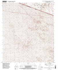
1996 Map of West of Quitobaquito Springs
USGS Topo · Published 2000About this map
The international boundary between United States of America Estados Unidos Mexicanos and Arizona Sonora cuts diagonally across this 1996 survey, defining a landscape shaped by conservation and military use. Much of the northern terrain is occupied by the Cabeza Prieta National Wildlife Refuge and the Cabeza Prieta Wilderness, areas preserved for their distinct desert ecosystems. To the north, the boundary of the Barry M. Goldwater Air Force Range indicates the region's role in national defense. The intermittent watercourse of Sonoita meanders through the southern portion of the quadrangle, highlighting the scarce but vital riparian patterns in this arid borderland. This map captures the intersection of sovereign borders and expansive federal land management in Pima County.
Find a feature on this map
9 named features on this map. Tap any name to fly to it.
Don’t see what you’re looking for? This feature index may not catch every label — zoom into the map to look around manually.
Map Details
Editions of this 1996 West of Quitobaquito Springs Map
This is the sole edition of this map. No revisions or reprints were ever made.
Other maps of this area

1953 · Ajo
USGS Topo · 1:250,000

1954 · Sonoyta
USGS Topo · 1:250,000

1957 · Ajo
USGS Topo · 1:250,000

1958 · Ajo
USGS Topo · 1:250,000

1962 · Ajo
USGS Topo · 1:250,000

1963 · Ajo
USGS Topo · 1:250,000

1963 · Quitobaquito Springs
USGS Topo · 1:62,500

1963 · Lukeville
USGS Topo · 1:250,000
1964 · Agua Dulce Mts
USGS Topo · 1:62,500

1965 · O'Neill Hills
USGS Topo · 1:62,500