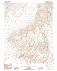
1987 Map of West of Teakettle Junction
USGS Topo · Published 1987About this map
Saline Valley and the towering Last Chance Range dominate this desert landscape in Inyo County during the late 1980s. The map captures a high-elevation wilderness defined by stark topography and specialized water sources, most notably at Upper Warm Spring. The presence of a Prospect near the western edge of the range suggests intermittent mineral exploration, a common thread in the history of this region. Navigating this environment relied heavily on primitive infrastructure, represented here by a network of 4wd tracks that traverse the valley floor and climb toward the mountain passes. This survey, based on 1984 photography, documents the area in a moment of stillness, serving as a primary source for understanding the remote access points and water locations essential for survival and industry in the high desert.
Find a feature on this map
10 named features on this map. Tap any name to fly to it.
Don’t see what you’re looking for? This feature index may not catch every label — zoom into the map to look around manually.
Map Details
Editions of this 1987 West of Teakettle Junction Map
This is the sole edition of this map. No revisions or reprints were ever made.
Other maps of this area

1908 · Ballarat
USGS Topo · 1:250,000

1913 · Ballarat
USGS Topo · 1:250,000

1948 · Death Valley
USGS Topo · 1:250,000

1950 · New York Butte
USGS Topo · 1:62,500

1950 · Ubehebe Peak
USGS Topo · 1:62,500

1951 · New York Butte
USGS Topo · 1:62,500

1951 · Ubehebe Peak
USGS Topo · 1:62,500

1951 · Waucoba Wash
USGS Topo · 1:62,500

1954 · Death Valley
USGS Topo · 1:250,000

1956 · Death Valley
USGS Topo · 1:250,000