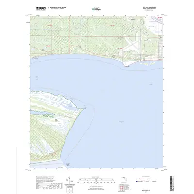
2024 Map of West Pass
USGS Topo · Published 2024About this map
Saint Vincent National Wildlife Refuge dominates this coastal landscape, preserving the barrier island terrain of Saint Vincent Island where the Florida Circumnavigational Paddling Trl skirts the shoreline. The map documents the intricate hydrography where Apalachicola Bay and Saint Vincent Sound meet at West Pass, a critical transition between the Gulf and the protected inland waters of the Intracoastal Waterway. To the north, the mainland shows a pattern of rural development around Franklin and Tilton, with the Apalachicola Regional Airport-Cleve Randolph Field serving as a significant modern landmark. Genealogists will find several burial grounds noted, including Hatch Cem on the island and Snow Hill Cem and Magnolia Cem on the mainland. The network of local roads like P and R Ranch Rd and Tilton Rd provides a detailed look at the modern accessibility of this historic waterfront region.
Find a feature on this map
58 named features on this map. Tap any name to fly to it.
Don’t see what you’re looking for? This feature index may not catch every label — zoom into the map to look around manually.
Map Details
Editions of this 2024 West Pass Map
This is the sole edition of this map. No revisions or reprints were ever made.
Other maps of this area

1943 · West Pass
USGS Topo · 1:31,680

1943 · Apalachicola
USGS Topo · 1:31,680

1943 · Indian Pass
USGS Topo · 1:24,000

1943 · Jackson River
USGS Topo · 1:24,000

1944 · Apalachicola
USGS Topo · 1:24,000

1945 · Cape St. George
USGS Topo · 1:31,680

1945 · Lake Wimico
USGS Topo · 1:31,680

1945 · Beverly
USGS Topo · 1:31,680

1945 · Jackson River
USGS Topo · 1:31,680

1945 · Indian Pass
USGS Topo · 1:31,680