
1967 Map of West Sumner
USGS Topo · Published 1976About this map
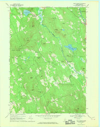
West Sumner and East Sumner anchor this 1960s survey of Oxford County, where the West Branch Nezinscot River winds through a landscape of prominent peaks and family-named landmarks. The terrain is defined by elevations like Streaked Mtn and Mt Mica, the latter featuring a Quarry indicating the area's geological importance. The map reveals a deeply rooted rural community, evidenced by numerous family cemeteries such as Stetson Cem, Prince Cem, and Whittemore Cem scattered across the hillsides.
Find a feature on this map
60 named features on this map. Tap any name to fly to it.
Don’t see what you’re looking for? This feature index may not catch every label — zoom into the map to look around manually.
Map Details
Editions of this 1967 West Sumner Map
2 editions found
Historical Maps of Paris Through Time
299 maps found

1896 Norway
Oxford County, ME

1909 Fryeburg
Oxford County, ME

1911 Bryant Pond
Oxford County, ME

1911 Buckfield
Oxford County, ME

1911 Fryeburg
Oxford County, ME

1913 Buckfield
Oxford County, ME

1914 Bryant Pond
Oxford County, ME

1927 Moose Bog
Oxford County, ME

1927 Rumford
Oxford County, ME

1930 Errol
Oxford County, ME

1930 Rumford
Oxford County, ME

1931 Cupsuptic
Oxford County, ME

1931 Moose Bog
Oxford County, ME

1934 Cupsuptic
Oxford County, ME

1935 Cupsuptic
Oxford County, ME

1940 Oquossoc
Oxford County, ME

1941 Fryeburg
Oxford County, ME

1942 Bryant Pond
Oxford County, ME

1942 Buckfield
Oxford County, ME

1942 Oquossoc
Oxford County, ME

1943 Old Speck Mtn
Oxford County, ME

1945 Old Speck Mtn
Oxford County, ME

1946 Norway
Oxford County, ME

1949 Norway
Oxford County, ME

1950 Cupsuptic
Oxford County, ME

1963 Center Lovell
Oxford County, ME

1963 Fryeburg
Oxford County, ME

1963 North Waterford
Oxford County, ME

1963 Pleasant Mtn
Oxford County, ME

1964 Brownfield
Oxford County, ME

1964 Hiram
Oxford County, ME

1967 Bryant Pond
Oxford County, ME

1967 Buckfield
Oxford County, ME

1967 Canton
Oxford County, ME

1967 Greenwood
Oxford County, ME

1967 Mount Zircon
Oxford County, ME

1967 West Paris
Oxford County, ME
1967 West Sumner
Oxford County, ME

1967 Worthley Pond
Oxford County, ME

1968 Dixfield
Oxford County, ME

1968 East Andover
Oxford County, ME

1968 Ellis Pond
Oxford County, ME

1969 Roxbury
Oxford County, ME

1969 Rumford
Oxford County, ME

1970 East Stoneham
Oxford County, ME

1970 Gilead
Oxford County, ME

1970 Speckled Mountain
Oxford County, ME

1976 Bosebuck Mountain
Oxford County, ME

1976 Moose Bog
Oxford County, ME

1976 Rump Mountain
Oxford County, ME

1977 Andover
Oxford County, ME

1977 B Pond
Oxford County, ME

1977 Kennebago
Oxford County, ME

1977 Lincoln Pond
Oxford County, ME

1977 Metallak Mountain
Oxford County, ME

1977 Middle Dam
Oxford County, ME

1977 Old Speck Mountain
Oxford County, ME

1977 Oquossoc
Oxford County, ME

1977 Parmachenee Lake
Oxford County, ME

1977 Puzzle Mountain
Oxford County, ME

1977 Richardson Pond
Oxford County, ME

1977 Twin Peaks
Oxford County, ME

1977 Wilsons Mills
Oxford County, ME

1980 Oxford
Oxford County, ME

1983 Norway
Oxford County, ME

1983 Waterford Flat
Oxford County, ME

1984 Andover
Oxford County, ME

1984 B Pond
Oxford County, ME

1984 Metallak Mtn
Oxford County, ME

1984 Middle Dam
Oxford County, ME

1984 Old Speck Mountain
Oxford County, ME

1984 Oquossoc
Oxford County, ME

1984 Puzzle Mountain
Oxford County, ME

1984 Richardson Pond
Oxford County, ME

1989 Bosebuck Mountain
Oxford County, ME

1989 Moose Bog
Oxford County, ME

1989 Rump Mountain
Oxford County, ME

1989 Wilsons Mills
Oxford County, ME

1990 Kennebago
Oxford County, ME

1990 Lincoln Pond
Oxford County, ME

1990 Parmachenee Lake
Oxford County, ME

1990 Twin Peaks
Oxford County, ME

1995 Center Lovell
Oxford County, ME

1995 East Stoneham
Oxford County, ME

1995 Gilead
Oxford County, ME

1995 North Waterford
Oxford County, ME

1995 Speckled Mountain
Oxford County, ME

1997 Kennebago
Oxford County, ME

1997 Metallak Mtn
Oxford County, ME

1997 Middle Dam
Oxford County, ME

1997 Oquossoc
Oxford County, ME

1997 Richardson Pond
Oxford County, ME

2000 Norway
Oxford County, ME

2000 Old Speck Mountain
Oxford County, ME

2011 Andover
Oxford County, ME

2011 Bosebuck Mountain
Oxford County, ME

2011 B Pond
Oxford County, ME

2011 Brownfield
Oxford County, ME

2011 Bryant Pond
Oxford County, ME

2011 Buckfield
Oxford County, ME

2011 Canton
Oxford County, ME

2011 Dixfield
Oxford County, ME

2011 East Andover
Oxford County, ME

2011 Ellis Pond
Oxford County, ME

2011 Fryeburg
Oxford County, ME

2011 Greenwood
Oxford County, ME

2011 Hiram
Oxford County, ME

2011 Kennebago
Oxford County, ME

2011 Lincoln Pond
Oxford County, ME

2011 Metallak Mountain
Oxford County, ME

2011 Middle Dam
Oxford County, ME

2011 Moose Bog
Oxford County, ME

2011 Mount Zircon
Oxford County, ME

2011 Norway
Oxford County, ME

2011 Old Speck Mountain
Oxford County, ME

2011 Oquossoc
Oxford County, ME

2011 Oxford
Oxford County, ME

2011 Parmachenee Lake
Oxford County, ME

2011 Pleasant Mountain
Oxford County, ME

2011 Puzzle Mountain
Oxford County, ME

2011 Richardson Pond
Oxford County, ME

2011 Roxbury
Oxford County, ME

2011 Rumford
Oxford County, ME

2011 Rump Mountain
Oxford County, ME

2011 Twin Peaks
Oxford County, ME

2011 Waterford Flat
Oxford County, ME

2011 West Paris
Oxford County, ME

2011 West Sumner
Oxford County, ME

2011 Wilsons Mills
Oxford County, ME

2011 Worthley Pond
Oxford County, ME

2012 Center Lovell
Oxford County, ME

2012 East Stoneham
Oxford County, ME

2012 Gilead
Oxford County, ME

2012 North Waterford
Oxford County, ME

2012 Speckled Mountain
Oxford County, ME

2014 Andover
Oxford County, ME

2014 Bosebuck Mountain
Oxford County, ME

2014 B Pond
Oxford County, ME

2014 Brownfield
Oxford County, ME

2014 Bryant Pond
Oxford County, ME

2014 Buckfield
Oxford County, ME

2014 Canton
Oxford County, ME

2014 Center Lovell
Oxford County, ME

2014 Dixfield
Oxford County, ME

2014 East Andover
Oxford County, ME

2014 East Stoneham
Oxford County, ME

2014 Ellis Pond
Oxford County, ME

2014 Fryeburg
Oxford County, ME

2014 Gilead
Oxford County, ME

2014 Greenwood
Oxford County, ME

2014 Hiram
Oxford County, ME

2014 Kennebago
Oxford County, ME

2014 Lincoln Pond
Oxford County, ME

2014 Metallak Mountain
Oxford County, ME

2014 Middle Dam
Oxford County, ME

2014 Moose Bog
Oxford County, ME

2014 Mount Zircon
Oxford County, ME

2014 North Waterford
Oxford County, ME

2014 Norway
Oxford County, ME

2014 Old Speck Mountain
Oxford County, ME

2014 Oquossoc
Oxford County, ME

2014 Oxford
Oxford County, ME

2014 Parmachenee Lake
Oxford County, ME

2014 Pleasant Mountain
Oxford County, ME

2014 Puzzle Mountain
Oxford County, ME

2014 Richardson Pond
Oxford County, ME

2014 Roxbury
Oxford County, ME

2014 Rumford
Oxford County, ME

2014 Rump Mountain
Oxford County, ME

2014 Speckled Mountain
Oxford County, ME

2014 Twin Peaks
Oxford County, ME

2014 Waterford Flat
Oxford County, ME

2014 West Paris
Oxford County, ME

2014 West Sumner
Oxford County, ME

2014 Wilsons Mills
Oxford County, ME

2014 Worthley Pond
Oxford County, ME

2018 Andover
Oxford County, ME

2018 Bosebuck Mountain
Oxford County, ME

2018 B Pond
Oxford County, ME

2018 Brownfield
Oxford County, ME

2018 Bryant Pond
Oxford County, ME

2018 Buckfield
Oxford County, ME

2018 Canton
Oxford County, ME

2018 Center Lovell
Oxford County, ME

2018 Dixfield
Oxford County, ME

2018 East Andover
Oxford County, ME

2018 East Stoneham
Oxford County, ME

2018 Ellis Pond
Oxford County, ME

2018 Fryeburg
Oxford County, ME

2018 Gilead
Oxford County, ME

2018 Greenwood
Oxford County, ME

2018 Hiram
Oxford County, ME

2018 Kennebago
Oxford County, ME

2018 Lincoln Pond
Oxford County, ME

2018 Metallak Mountain
Oxford County, ME

2018 Middle Dam
Oxford County, ME

2018 Moose Bog
Oxford County, ME

2018 Mount Zircon
Oxford County, ME

2018 North Waterford
Oxford County, ME

2018 Norway
Oxford County, ME

2018 Old Speck Mountain
Oxford County, ME

2018 Oquossoc
Oxford County, ME

2018 Oxford
Oxford County, ME

2018 Parmachenee Lake
Oxford County, ME

2018 Pleasant Mountain
Oxford County, ME

2018 Puzzle Mountain
Oxford County, ME

2018 Richardson Pond
Oxford County, ME

2018 Roxbury
Oxford County, ME

2018 Rumford
Oxford County, ME

2018 Rump Mountain
Oxford County, ME

2018 Speckled Mountain
Oxford County, ME

2018 Twin Peaks
Oxford County, ME

2018 Waterford Flat
Oxford County, ME

2018 West Paris
Oxford County, ME

2018 West Sumner
Oxford County, ME

2018 Wilsons Mills
Oxford County, ME

2018 Worthley Pond
Oxford County, ME

2021 Andover
Oxford County, ME

2021 Bosebuck Mountain
Oxford County, ME

2021 B Pond
Oxford County, ME

2021 Brownfield
Oxford County, ME

2021 Bryant Pond
Oxford County, ME

2021 Buckfield
Oxford County, ME

2021 Canton
Oxford County, ME

2021 Center Lovell
Oxford County, ME

2021 Dixfield
Oxford County, ME

2021 East Andover
Oxford County, ME

2021 East Stoneham
Oxford County, ME

2021 Ellis Pond
Oxford County, ME

2021 Fryeburg
Oxford County, ME

2021 Gilead
Oxford County, ME

2021 Greenwood
Oxford County, ME

2021 Hiram
Oxford County, ME

2021 Kennebago
Oxford County, ME

2021 Lincoln Pond
Oxford County, ME

2021 Metallak Mountain
Oxford County, ME

2021 Middle Dam
Oxford County, ME

2021 Moose Bog
Oxford County, ME

2021 Mount Zircon
Oxford County, ME

2021 North Waterford
Oxford County, ME

2021 Norway
Oxford County, ME

2021 Old Speck Mountain
Oxford County, ME

2021 Oquossoc
Oxford County, ME

2021 Oxford
Oxford County, ME

2021 Parmachenee Lake
Oxford County, ME

2021 Pleasant Mountain
Oxford County, ME

2021 Puzzle Mountain
Oxford County, ME

2021 Richardson Pond
Oxford County, ME

2021 Roxbury
Oxford County, ME

2021 Rumford
Oxford County, ME

2021 Rump Mountain
Oxford County, ME

2021 Speckled Mountain
Oxford County, ME

2021 Twin Peaks
Oxford County, ME

2021 Waterford Flat
Oxford County, ME

2021 West Paris
Oxford County, ME

2021 West Sumner
Oxford County, ME

2021 Wilsons Mills
Oxford County, ME

2021 Worthley Pond
Oxford County, ME

2024 Andover
Oxford County, ME

2024 Bosebuck Mountain
Oxford County, ME

2024 B Pond
Oxford County, ME

2024 Brownfield
Oxford County, ME

2024 Bryant Pond
Oxford County, ME

2024 Buckfield
Oxford County, ME

2024 Canton
Oxford County, ME

2024 Center Lovell
Oxford County, ME

2024 Dixfield
Oxford County, ME

2024 East Andover
Oxford County, ME

2024 East Stoneham
Oxford County, ME

2024 Ellis Pond
Oxford County, ME

2024 Fryeburg
Oxford County, ME

2024 Gilead
Oxford County, ME

2024 Greenwood
Oxford County, ME

2024 Hiram
Oxford County, ME

2024 Kennebago
Oxford County, ME

2024 Lincoln Pond
Oxford County, ME

2024 Metallak Mountain
Oxford County, ME

2024 Middle Dam
Oxford County, ME

2024 Moose Bog
Oxford County, ME

2024 Mount Zircon
Oxford County, ME

2024 North Waterford
Oxford County, ME

2024 Norway
Oxford County, ME

2024 Old Speck Mountain
Oxford County, ME

2024 Oquossoc
Oxford County, ME

2024 Oxford
Oxford County, ME

2024 Parmachenee Lake
Oxford County, ME

2024 Pleasant Mountain
Oxford County, ME

2024 Puzzle Mountain
Oxford County, ME

2024 Richardson Pond
Oxford County, ME

2024 Roxbury
Oxford County, ME

2024 Rumford
Oxford County, ME

2024 Rump Mountain
Oxford County, ME

2024 Speckled Mountain
Oxford County, ME

2024 Twin Peaks
Oxford County, ME

2024 Waterford Flat
Oxford County, ME

2024 West Paris
Oxford County, ME

2024 West Sumner
Oxford County, ME

2024 Wilsons Mills
Oxford County, ME

2024 Worthley Pond
Oxford County, ME