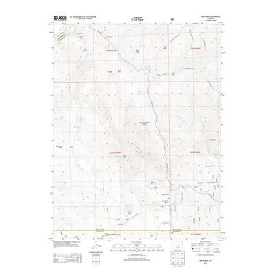
2013 Map of Westcreek
USGS Topo · Published 2013About this map
The mountain settlement of Westcreek and the expansive Pike National Forest define this 2013 survey of the Douglas County backcountry. The landscape is marked by a network of ranching and recreational sites, including Grandview Resort, Pollock Ranch, and Shady Brook Camp, illustrating the region's transition from early homesteading to a modern mix of private holdings and public land. Significant geological landmarks like Thunder Butte and Sheep Nose dominate the horizon, while drainage patterns from Horse Cr and West Cr dictate the placement of roads like State Hwy 67. Researchers can trace the intersections of historic land divisions like t010s r070w across the Jefferson and Teller county lines. Small-scale water management is evidenced by the J-O Hill Reservoir, situated near residential clusters along Westcreek Rd and Trout Creek Ranch Rd.
Find a feature on this map
53 named features on this map. Tap any name to fly to it.
Don’t see what you’re looking for? This feature index may not catch every label — zoom into the map to look around manually.
Map Details
Editions of this 2013 Westcreek Map
This is the sole edition of this map. No revisions or reprints were ever made.
Other maps of this area

1893 · Platte Canyon
USGS Topo · 1:125,000

1953 · Denver
USGS Topo · 1:250,000

1954 · Devils Head
USGS Topo · 1:24,000

1954 · Deckers
USGS Topo · 1:24,000

1954 · Green Mountain
USGS Topo · 1:24,000

1954 · Mount Deception
USGS Topo · 1:24,000

1954 · Signal Butte
USGS Topo · 1:24,000
1956 · Dakan Mountain
USGS Topo · 1:24,000

1956 · Hackett Mountain
USGS Topo · 1:24,000
1956 · Cheesman Lake
USGS Topo · 1:24,000