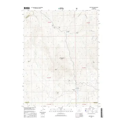
2016 Map of Westcreek
USGS Topo · Published 2016About this map
Westcreek sits at the heart of this high-country landscape, serving as a primary point of reference within the vast Pike National Forest. The topography is defined by a dense network of drainages and named peaks, including the prominent Thunder Butte, Bell Rock, and Sheep Nose. Water sources are vital to the area's layout, with Horse Cr and Fourmile Cr carving through the terrain, while the J O Hill Reservoir provides a managed water feature near the settlement center.
Find a feature on this map
30 named features on this map. Tap any name to fly to it.
Don’t see what you’re looking for? This feature index may not catch every label — zoom into the map to look around manually.
Map Details
Editions of this 2016 Westcreek Map
This is the sole edition of this map. No revisions or reprints were ever made.
Other maps of this area

1893 · Platte Canyon
USGS Topo · 1:125,000

1953 · Denver
USGS Topo · 1:250,000

1954 · Devils Head
USGS Topo · 1:24,000

1954 · Deckers
USGS Topo · 1:24,000

1954 · Green Mountain
USGS Topo · 1:24,000

1954 · Mount Deception
USGS Topo · 1:24,000

1954 · Signal Butte
USGS Topo · 1:24,000
1956 · Dakan Mountain
USGS Topo · 1:24,000

1956 · Hackett Mountain
USGS Topo · 1:24,000
1956 · Cheesman Lake
USGS Topo · 1:24,000