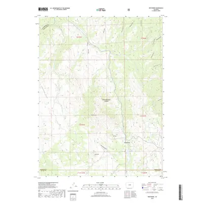
2019 Map of Westcreek
USGS Topo · Published 2019About this map
The mountain settlement of Westcreek serves as a focal point within the Pike National Forest, situated near the southern boundary of Douglas County. This 2019 survey documents a landscape defined by sharp elevation changes and numerous drainage systems, including Horse Cr, Trout Cr, and Fourmile Cr. The terrain is punctuated by distinctive geological landmarks such as Thunder Butte, Bell Rock, and Sheep Nose, which provide clear reference points for navigation and land management in this portion of the Front Range.
Find a feature on this map
31 named features on this map. Tap any name to fly to it.
Don’t see what you’re looking for? This feature index may not catch every label — zoom into the map to look around manually.
Map Details
Editions of this 2019 Westcreek Map
This is the sole edition of this map. No revisions or reprints were ever made.
Other maps of this area

1893 · Platte Canyon
USGS Topo · 1:125,000

1953 · Denver
USGS Topo · 1:250,000

1954 · Devils Head
USGS Topo · 1:24,000

1954 · Deckers
USGS Topo · 1:24,000

1954 · Green Mountain
USGS Topo · 1:24,000

1954 · Mount Deception
USGS Topo · 1:24,000

1954 · Signal Butte
USGS Topo · 1:24,000
1956 · Dakan Mountain
USGS Topo · 1:24,000

1956 · Hackett Mountain
USGS Topo · 1:24,000
1956 · Cheesman Lake
USGS Topo · 1:24,000