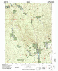
1994 Map of Westcreek
USGS Topo · Published 1998About this map
The South Platte River carves through the north-central portion of this landscape, its path mirrored by the South Platte River Road near the settlement of Deckers. This area, within the Pike National Forest, shows a transition from river-bottom activity to high-altitude landmarks. Significant topographic features like Thunder Butte and Platte Peak dominate the skyline, while smaller geological markers such as Bell Rock and Sheep Nose provide orientation in the southern reaches. Recreational and communal sites are well-documented, including the Shady Brook Camp (YMCA), Grandview Resort, and the community of Westcreek. The map also captures several drainages like Horse Creek and Trout Creek feeding into the main river system, alongside a local Quarry that suggests the area's small-scale industrial history. It serves as a detailed record of the intersections between the Jefferson, Douglas, and Teller county lines during the late twentieth century.
Find a feature on this map
29 named features on this map. Tap any name to fly to it.
Don’t see what you’re looking for? This feature index may not catch every label — zoom into the map to look around manually.
Map Details
Editions of this 1994 Westcreek Map
This is the sole edition of this map. No revisions or reprints were ever made.
Other maps of this area

1893 · Platte Canyon
USGS Topo · 1:125,000

1953 · Denver
USGS Topo · 1:250,000

1954 · Devils Head
USGS Topo · 1:24,000

1954 · Deckers
USGS Topo · 1:24,000

1954 · Green Mountain
USGS Topo · 1:24,000

1954 · Mount Deception
USGS Topo · 1:24,000

1954 · Signal Butte
USGS Topo · 1:24,000
1956 · Dakan Mountain
USGS Topo · 1:24,000

1956 · Hackett Mountain
USGS Topo · 1:24,000
1956 · Cheesman Lake
USGS Topo · 1:24,000