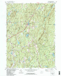
1983 Map of Westford
USGS Topo · Published 1984About this map
Nipmuck State Forest and Natchaug State Forest dominate this landscape on the border of Tolland and Windham Counties, revealing a region defined by its conservation areas and water resources. The 1980s terrain is characterized by a high concentration of named ponds and brooks, including Lake Chaffee and the winding East Branch Mount Hope River. For genealogists and local historians, several burial sites are documented, such as the Swamp Burying Ground and Moose Meadow Cem near Willington.
Find a feature on this map
79 named features on this map. Tap any name to fly to it.
Don’t see what you’re looking for? This feature index may not catch every label — zoom into the map to look around manually.
Map Details
Editions of this 1983 Westford Map
This is the sole edition of this map. No revisions or reprints were ever made.
Other maps of this area

1887 · Brookfield
USGS Topo · 1:62,500

1887 · Palmer
USGS Topo · 1:62,500

1889 · Palmer
USGS Topo · 1:62,500

1890 · Brookfield
USGS Topo · 1:62,500

1892 · Woodstock
USGS Topo · 1:62,500

1892 · Tolland
USGS Topo · 1:62,500

1893 · Palmer
USGS Topo · 1:62,500

1893 · Brookfield
USGS Topo · 1:62,500

1908 · Ware
USGS Topo · 1:125,000

1915 · Brookfield
USGS Topo · 1:62,500