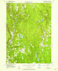
1955 Map of Westhampton
USGS Topo · Published 1957About this map
Westhampton and the eastern slopes of the Berkshire foothills are documented here during the mid-1950s, revealing a landscape defined by small upland settlements and the early implementation of regional water management. Much of the western terrain along the Westfield River is designated as Federal Flood Control Land, a move that dramatically reshaped the land use around Goss Heights and Norwich. For genealogists and local researchers, the map preserves the exact locations of family-named plots such as Torrey Cem and Bofat Meadow Cem, as well as relic industry sites like Bisbee Mill on the Dead Branch. The network of backroads, including Kings Highway and Stage Road, connects isolated peaks like Mt Pisgah and Spruce Hill, providing a clear view of the rural township structure before modern suburban development reached these Hampshire County highlands.
Find a feature on this map
74 named features on this map. Tap any name to fly to it.
Don’t see what you’re looking for? This feature index may not catch every label — zoom into the map to look around manually.
Map Details
Editions of this 1955 Westhampton Map
2 editions found
Other maps of this area

1885 · Northampton
USGS Topo · 1:62,500

1886 · Springfield
USGS Topo · 1:62,500

1886 · Chesterfield
USGS Topo · 1:62,500

1886 · Northampton
USGS Topo · 1:62,500

1887 · Granville
USGS Topo · 1:62,500

1888 · Chesterfield
USGS Topo · 1:62,500

1889 · Springfield
USGS Topo · 1:62,500

1889 · Granville
USGS Topo · 1:62,500

1891 · Northampton
USGS Topo · 1:62,500

1893 · Northampton
USGS Topo · 1:62,500