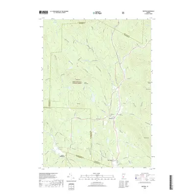
2018 Map of Weston
USGS Topo · Published 2018About this map
Weston sits at the junction of the West River and Trout Club Rd, serving as a central hub for this portion of the Vermont highlands. The landscape is defined by the high peaks of the Green Mountains, including Terrible Mtn and Markham Mtn, which frame the narrow valley settlements. Much of the western territory is protected within the Green Mountain National Forest, where features like Peabody Hill and Rootbeer Ridge overlook secluded water bodies such as Moses Pond and Peabody Pond. For those tracing local families, the map identifies several distinct burial grounds including Forefathers Cem, Maple Grove Cem, and Island Cem. To the south, the settlement of North Landgrove marks a secondary cluster of development along Landgrove Rd and Utley Brook. The distribution of residential roads and named hills like Morgan Hill and Holt Mtn reflects a long history of mountain farming and timber work.
Find a feature on this map
79 named features on this map. Tap any name to fly to it.
Don’t see what you’re looking for? This feature index may not catch every label — zoom into the map to look around manually.
Map Details
Editions of this 2018 Weston Map
This is the sole edition of this map. No revisions or reprints were ever made.
Other maps of this area

1893 · Wallingford
USGS Topo · 1:62,500

1894 · Londonderry
USGS Topo · 1:62,500

1899 · Londonderry
USGS Topo · 1:62,500

1928 · Ludlow
USGS Topo · 1:48,000

1929 · Ludlow
USGS Topo · 1:62,500

1930 · Saxtons River
USGS Topo · 1:48,000

1932 · Ludlow
USGS Topo · 1:62,500

1933 · Saxtons River
USGS Topo · 1:62,500

1950 · Glens Falls
USGS Topo · 1:250,000

1955 · Wallingford
USGS Topo · 1:62,500