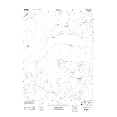
2012 Map of Westville
USGS Topo · Published 2012About this map
Westville sits atop the high ground of the Forest Hill Divide in this rugged section of Placer County, where the landscape is defined by the steep descents into Humbug Canyon and the N Fork American River. The map captures a high-country region where historic mining and timber operations have left a permanent mark on the terrain. Evidence of significant 19th-century hydraulic engineering remains visible through the China Wall Iowa Hill Ditch and the Breece and Wheeler Ditch, which once channeled water across the ridges. Small settlements and camps like Damascus, Forks House, and Rawhide are spaced along the divide, while industrial relics such as the Osborne Tunnel and Maxwell Sawmill highlight the area's extractive history. From the peaks of Sawtooth Ridge to the depths of Italian Bar, the map documents a complex network of forest roads like Pioneer Mine Rd connecting these remote outposts.
Find a feature on this map
49 named features on this map. Tap any name to fly to it.
Don’t see what you’re looking for? This feature index may not catch every label — zoom into the map to look around manually.
Map Details
Editions of this 2012 Westville Map
This is the sole edition of this map. No revisions or reprints were ever made.
Other maps of this area

1891 · Colfax
USGS Topo · 1:125,000

1892 · Colfax
USGS Topo · 1:125,000

1894 · Colfax
USGS Topo · 1:125,000

1898 · Colfax
USGS Topo · 1:125,000

1900 · Colfax
USGS Topo · 1:125,000

1902 · Colfax
USGS Topo · 1:125,000

1938 · Colfax
USGS Topo · 1:125,000
1948 · Foresthill
USGS Topo · 1:24,000
1949 · Foresthill
USGS Topo · 1:24,000
1950 · Colfax
USGS Topo · 1:62,500