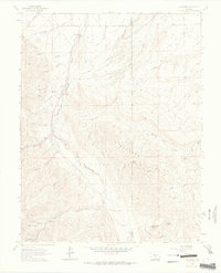
1963 Map of Wetmore
USGS Topo · Published 1965About this map
Wetmore and Greenwood anchor the landscape of this mid-century survey along the eastern edge of the San Isabel National Forest. The topography is defined by the complex drainage systems of Hardscrabble Creek, which splits into North, Middle, and South branches as it cuts through the terrain. The area shows a transition from small settlements and agricultural sites like the Don K Ranch to the more primitive recreational and forestry land to the west. Cultural markers such as the Florence Picnic Area and family-named landmarks like Bohn Gulch and Watson Gulch indicate the local human footprint on this drainage basin. Notable elevations including Bears Head, Big Red Butte, and Little Red Butte stand as significant navigational points, while the Highline Trail and Rudolph Mtn Trail suggest the established routes used by foresters and early outdoorsmen.
Find a feature on this map
40 named features on this map. Tap any name to fly to it.
Don’t see what you’re looking for? This feature index may not catch every label — zoom into the map to look around manually.
Map Details
Editions of this 1963 Wetmore Map
3 editions found

Other maps of this area

1889 · Canon City
USGS Topo · 1:125,000

1891 · Pueblo
USGS Topo · 1:125,000

1892 · Canon City
USGS Topo · 1:125,000

1894 · Pueblo
USGS Topo · 1:125,000

1896 · Pueblo
USGS Topo · 1:125,000

1897 · Pueblo
USGS Topo · 1:125,000

1954 · Pueblo
USGS Topo · 1:250,000

1957 · Pueblo
USGS Topo · 1:250,000

1958 · Pueblo
USGS Topo · 1:250,000

1959 · Rockvale
USGS Topo · 1:24,000